A wide lineup of measurement tools to respond to diversified needs at different sites3D Measurement
- IT & DX
- Maintenance & Management
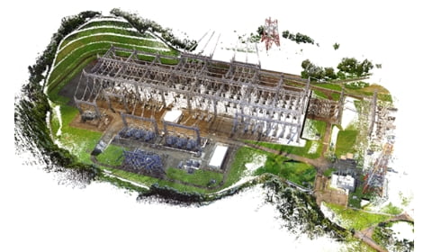
We offer services for measuring your worksite using a 3D laser scanner, creating drawings or models based on the data, and analyzing them. We will choose the most suitable measurement equipment from our wide lineup of tools. The acquired measurement data (point cloud) can also be viewed and measured with a free viewer.
Point
- We support a wide range of measurement sizes.
- We can perform measurements periodically to record, analyze, and evaluate changes over time.
- We support not only measurements, but also model creation and data utilization.
- We also have extensive experience in drone measurement. We offer both drone measurement and drone laser measurement.
- We have obtained the Pilot Skills Certificate and the Safe Flight Manager Certificate from JUIDA, a school accredited by the Ministry of Land, Infrastructure, Transport and Tourism. (Four of our staff have obtained these certificates.)
We can solve these problems!
- The site is old, and the diagrams have been lost.
- Maintenance diagrams do not accurately reflect the site.
- You would like to obtain 3D data of the site.
- It’s difficult to measure in high places without scaffolding.
- You would like to examine space requirements from your desk
- You would like to monitor sinking or displacement.
A one-stop service for 3D measurement
A one-stop service for 3D measurement
Measurement
360-degree panoramic view / Point cloud view
- ・3D laser scanner
- ・MMS
- ・UVA

Creation of diagrams or models
Provision of data search optimization software (NaviPortal)
Provision of equipment isolation simulation software (IsolationNavi)
Provision of 3D construction simulation software
(3D Construction Machinery Navigation)
- ・2D drawing creation
- ・3D modeling
- ・BIM/CIM data creation

Analysis
360-degree panoramic view / Point cloud view
- ・3D liquefaction analysis (Multiphysics analysis of structures and soils)
- ・3D ground analysis model
- ・Noise assessment
- ・Air flow analysis
- ・Thermal analysis of large spaces


Overview of Our Technology and Services
-

Lattice / materials survey -

Ground surface displacement survey -

Water tunnel displacement survey -

Material displacement survey -

Colored contour modeling of the ground surface -

Colored counter modeling of tunnel displacement -

3D measurement of large areas -

Measurement of tower shape change -

Assessment of construction errors
Track Record
- Drone measurement
- Structural survey of nuclear power plants for tornado countermeasures
- Structural corrosion survey
- Laser measurement
- Measurement of plant facility condition for renovation
- Measurement of lattice tower displacement
- Lattice tower structural survey
- Measurement of water turbine generator condition for detailed design of the foundation
- Construction accuracy survey of fluid experimental facility
- Measurement of water tunnel shape change
- Wind turbine tower safety survey
- Measurement of subsidence
- Ancient tomb shape survey
Data Provision Format
We will provide an estimate after talking with you.
- Raw data
- Registration data
- Form of Web viewer
- 3D mesh model
- 3D animation
- Geophysical model (Colored contour model)
From Our Customers
We previously used a total station to measure points on a grid but using 3D laser measurement allowed us to see the surface deformation. We were very pleased with both efficiency and quality.